In August, the U.S. Forest Service proposed rescinding the 2001 Roadless Rule, which restricts local forest managers from authorizing road construction, reconstruction, and timber harvesting on roughly 58.5 million acres of inventoried roadless areas in national forests, nearly a third of all national forest acreage. Originally adopted as a conservation policy to preserve existing roadless areas, the agency now argues that these restrictions limit the tools available to Forest Service managers for improving forest health and managing wildfire risk, particularly by constraining thinning projects, prescribed burns, and road access for suppression efforts.
This analysis examines fire-related trade-offs associated with the Roadless Rule’s restrictions. Using descriptive statistics, we compare wildfire outcomes across three categories of Forest Service land: inventoried roadless areas, managed forests, and wilderness areas. Our analysis is not intended to estimate the causal effect of the Roadless Rule or of constructing additional roads. Instead, we use descriptive evidence to identify the trade-offs associated with restricting road access and forest management. Our findings suggest that a more targeted policy could better balance the potential costs and benefits across different landscapes.
Highlights
Road Access and Ignitions: Existing research on human and road access identifies competing effects. While limited access to roadless areas may make initial firefighting efforts more difficult, rescinding the Roadless Rule could lead to more ignitions. A Fire Ecology study by Aplet et al. earlier this year found that ignition density is roughly four times higher within 50 meters of roads than in inventoried roadless areas, particularly for human-caused fires.1Aplet, G.H., Hartger, P. and Dietz, M.S., 2026. Three-decade record of contiguous-U.S. national forest wildfires indicates increased density of ignitions near roads. Fire Ecology, 22(1), Article 8. https://doi.org/10.1186/s42408-026-00450-2.
Community Risk: Inventoried roadless areas contain roughly 74,000 acres, or 2 percent of national forest acreage in direct-exposure zones—areas with buildings or populated land directly adjacent to flammable wildland vegetation—and 7.3 million acres, or 16 percent of acreage in broader wildfire-transmission zones, which include vegetated land within approximately 2.4 kilometers of clusters of buildings, where wildfire fuels may cause fires to spread into populated zones.
Emissions Risk: Fires igniting in roadless areas generate less fine inhalable particulate matter (PM₂.₅) in total than fires igniting in managed forests, although associated emissions per acre of roadless land are about one-third higher.
Suppression Costs and Damages: From 2010–2020, fires that ignited in inventoried roadless areas accounted for roughly 25 percent of reported suppression costs across Forest Service lands ($3.9 billion of a total of $15.6 billion). These fires were associated with approximately 1,700 reported lost properties, or about 11 percent of the nearly 16,000 total property losses reported. Suppression costs per acre of roadless land are higher than for managed forests but lower than for wilderness areas. These outcomes are assigned by ignition location, not by assessing all areas where fires eventually burned, suppression resources were used, or damages occurred
Analysis
This analysis is organized around three questions:
- What wildfire outcomes are associated with fires originating in inventoried roadless areas?
- How much do inventoried roadless areas overlap with community wildfire risk-reduction zones?
- What might change if road access expands?
These questions are relevant to the suppression costs, property losses, and smoke emissions associated with fires originating in roadless areas. We use existing research to consider how access may affect both suppression and ignitions. Better access could improve initial firefighting efforts and make some fuel treatments easier. It could also fragment habitat and increase human-caused ignitions. The available evidence presented here does not allow us to determine conclusively whether the benefits would outweigh the costs in particular areas.
Categorization of National Forest Lands
This analysis distinguishes among three categories of national forest lands:
- Inventoried Roadless Areas (or simply “Roadless Areas”)
- Wilderness Areas
- Managed National Forests
Separating inventoried roadless areas from wilderness areas is important for evaluating the policy proposal. Wilderness is generally regulated under the Wilderness Act and is not affected by the proposed rescission of the Roadless Rule. Johnston et al., by contrast, combine inventoried roadless areas and wilderness.2Johnston, J.D., Kilbride, J.B., Meigs, G.W., Dunn, C.J. and Kennedy, R.E., 2021. Does conserving roadless wildland increase wildfire activity in western US national forests? Environmental Research Letters, 16(8), p.084040. (Submitted into the Congressional record for the House Natural Resources Subcommittee on National Parks, Forests, and Public Lands hearing on H.R. 279, the Roadless Area Conservation Act of 2021, May 11, 2022.)
Question 1: What Wildfire Outcomes Are Associated with Fires Originating in Inventoried Roadless Areas?
We use two complementary datasets to describe the economic burden of wildfires across different federal land designations in the western U.S., which contains more than 70 percent of roadless area. The first is the ICS-209 incident-reporting system, which contains operational reports for wildfires that become large or significant incidents. Wildfires in this dataset are a small percentage of total wildfires (1 percent), but represent 85 percent of suppression costs and 95 percent of acres burned. We aggregate reported suppression expenditures and property losses for 2010–2020 using the research-ready data provided by St. Denis et al.3St. Denis, L.A., Short, K.C., McConnell, K., Cook, M.C., Mietkiewicz, N.P., Buckland, M. and Balch, J.K., 2023. All-hazards dataset mined from the US National Incident Management System 1999–2020. Scientific data, 10(1), p.112. https://pmc.ncbi.nlm.nih.gov/articles/PMC9958120/ The second source is the Wildland Fire Emissions Information System (WFEIS). We use WFEIS data from 2010–20234Michigan Technological University. Wildland Fire Emissions Information System (WFEIS). https://wfeis.mtri.org/, linked to fire perimeters from the Monitoring Trends in Burn Severity (MTBS)5U.S. Geological Survey and U.S. Department of Agriculture Forest Service. Monitoring Trends in Burn Severity (MTBS). https://www.mtbs.gov/ dataset, to quantify estimated PM₂.₅ emissions associated with each fire.
Several data limitations are important to note: Each fire’s reported suppression costs, reported property losses, and estimated emissions are assigned to the land designation that contains its ignition point. The data do not reveal where a fire burned, where suppression resources were used, what assets the spending protected, or where damages occurred.6Furthermore, the suppression results cover only ICS-209 incidents successfully linked to the fire and land-designation data; matching rates and the share of total western suppression spending captured by the sample are not reported. Cross-boundary fires can shift outcomes in either direction among categories. ICS-209 costs are operational estimates, and the selected cost field and dollar-year treatment are not documented here. Finally, outcomes divided by total land acreage are descriptive burden-per-land-acre measures, not costs per acre burned, marginal management costs, or treatment effects.
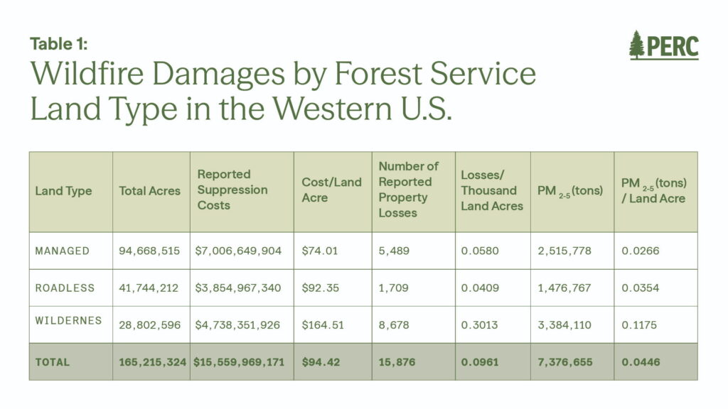
- Among matched ICS-209 incidents, fires igniting in roadless areas represent roughly 25 percent of reported suppression costs, amounting to nearly $3.9 billion.
- Associated suppression costs per acre of roadless land ($92) are higher than for managed forests ($74) but lower than for wilderness ($165). This is calculated using all land in each category, not acres burned. Differences may reflect ignition frequency, fire size, terrain, access, suppression decisions, or assets threatened.
- Reported property losses in roadless areas are smaller in absolute terms (about 1,700 properties, or 11 percent of the matched total) than in other land categories.
- Estimated smoke emissions total about 1.5 million tons of PM₂.₅ (20 percent of the total). Associated emissions per acre of roadless land are about 33 percent higher than for managed forests.
Johnston et al. find that fires in a combined category of wilderness and inventoried roadless areas were more likely to escape initial suppression and, once escaped, were about one-third larger than fires originating in roaded forests.7Johnston, J.D., Kilbride, J.B., Meigs, G.W., Dunn, C.J. and Kennedy, R.E., 2021. Does conserving roadless wildland increase wildfire activity in western US national forests? Environmental Research Letters, 16(8), p.084040. (Submitted into the Congressional record for the House Natural Resources Subcommittee on National Parks, Forests, and Public Lands hearing on H.R. 279, the Roadless Area Conservation Act of 2021, May 11, 2022.) These patterns may help explain higher suppression costs. However, the study does not analyze costs, separate wilderness from inventoried roadless areas, or identify the causal effect of road access.
Question 2: How Much Do Inventoried Roadless Areas Overlap with Community Wildfire Risk-Reduction Zones?
To describe where fire mitigation may protect homes and communities, we use the Wildfire Risk to Communities dataset from Dillon et al.8Dillon, G.K., Lazarz, M.T., Karau, E.C., Story, S.J., Pohl, K.A., 2024. Wildfire Risk to Communities: Community Wildfire Risk Reduction Zones for the United States. Updated 27 May 2025. Fort Collins, CO: Forest Service Research Data Archive. https://doi.org/10.2737/RDS-2024-0030. The data categorize several types of zones by combining wildfire likelihood with proximity to populated areas and distinguish places where different types of mitigation may be useful.
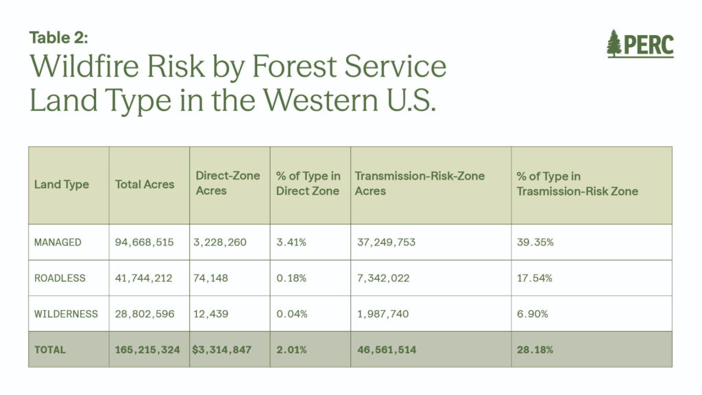
We first define land as having Direct Risk if it falls in either the Direct Exposure or Indirect Exposure zones. Direct Exposure refers to areas adjacent to flammable wildland vegetation where homes are exposed to both embers and direct flame or radiant heat. Indirect Exposure includes areas within approximately 1.5 kilometers of large, contiguous flammable wildland vegetation where the land cover is less conducive to fire spread (e.g., developed, non-burnable surfaces), so risk is mostly from embers or home-to-home ignition.
As a broader measure, we also include land in the Wildfire Transmission Zone, which captures vegetated land within about 2.4 kilometers of clusters of buildings (defined roughly as areas with more than one building per 40 acres), where fuels may help fires spread into populated zones. We label this combined measure Transmission Risk in the table below.
- Roadless areas contain about 74,000 acres classified in the direct-exposure zones, roughly 2 percent of all national forest acres in those zones. Approximately 0.18 percent of inventoried roadless acreage falls in a direct-exposure zone, compared with 3.41 percent of managed-forest acreage.
- Roadless areas contain about 7.3 million acres in the wildfire-transmission zone, roughly 16 percent of national forest transmission-zone acreage. Approximately 17.54 percent of inventoried roadless acreage falls in this zone, compared with 39.35 percent of managed-forest acreage and 6.90 percent of wilderness acreage.
Very little roadless acreage lies in the direct-exposure zones, so treatments there would have a limited direct role in protecting homes. The larger overlap with the transmission zone means that some roadless areas may still affect whether fire reaches communities. The analysis does not show whether fuel treatments, road construction, or rescinding the Roadless Rule would reduce structure loss or overall community risk. However, recent evidence suggests that fuel treatments on Forest Service lands are a cost-effective means of limiting wildfire spread, protecting communities, and reducing suppression costs.9Strabo, F., Bryan, C. and Reimer, M.N., 2026. Wildfire damages and the cost-effective role of forest fuel treatments. Science, 392(6798), pp.629-635.; Strabo, F. and Reimer, M.N., 2026. Before the burn: The economic benefits of fuel-reduction treatments in wildfire-prone forests. The Economic Journal, p.ueag037. Some of the differences also reflect terrain and proximity to development.
These measures capture risks to homes and communities, but not the potential ecological damage from wildfire. Although wildfire is natural and often beneficial, frequent or severe fires can harm watersheds, habitat, and forest regeneration even when they pose little risk to homes.
Question 3: What Might Change if Road Access Expands?
The first two questions describe current outcomes and geographic overlap, but they do not show how building or opening roads would change wildfire outcomes. Aplet, Hartger, and Dietz examine this question using InFORM wildfire-occurrence data from 1992–2024 across all eight contiguous U.S. Forest Service regions.10Aplet, G.H., Hartger, P. and Dietz, M.S., 2026. Three-decade record of contiguous-U.S. national forest wildfires indicates increased density of ignitions near roads. Fire Ecology, 22(1), Article 8. https://doi.org/10.1186/s42408-026-00450-2.
Ignition density is lowest in designated wilderness, at 1.75 fires per 1,000 hectares, and inventoried roadless areas, at 1.97 fires per 1,000 hectares. It rises to 3.50 fires on other national forest land and 7.99 fires within 50 meters of a road, roughly four times the roadless rate. Ignitions decline with distance from roads, especially for human-caused fires. Fires are larger on average in wilderness and roadless areas than in managed areas, although the largest 2 percent of fires are similar in size across land designations.
Overall, the latest research finds patterns that run in opposite directions. On the one hand, roadless and wilderness areas have fewer ignitions. On the other hand, fires that start in non-managed areas are more likely to escape initial suppression and grow larger. Relatedly, areas near roads have more ignitions, particularly from human causes, but smaller fires on average.
These are correlations, not estimates of what would happen if new roads were built. Areas near existing roads also differ in development, historical land use, detection, and other ways. No existing study tells us whether potential suppression benefits of additional roads on national forest lands would outweigh the increase in ignition risk they would bring.

Conclusion
Much of the current Roadless Rule debate centers on whether its nationwide restrictions should remain in their current form or be rescinded. Our analysis shows that the wildfire-management and conservation trade-offs associated with roadless protections vary substantially across landscapes:
- Potential benefits of greater flexibility: Fires igniting in roadless areas account for roughly 25 percent of reported suppression costs on Forest Service lands, and approximately 7.3 million roadless acres lie within wildfire-transmission zones. Greater management flexibility in some areas could facilitate fuel treatments and initial suppression, particularly where wildfires may spread toward communities.
- Potential costs and limitations of expanded access: Human-caused ignitions are substantially more common near roads, suggesting that expanded road access could increase ignition risk while also imposing ecological, construction, and ongoing maintenance costs. Moreover, only about 74,000 roadless acres lie within direct-exposure zones near developed areas, suggesting that the community-protection benefits of expanded management may be geographically limited.
The wildfire-related evidence does not establish how these competing considerations should be resolved in particular areas or which regulatory mechanism is preferable. Various approaches could allow local benefits and costs to receive greater consideration, including clarifying existing exceptions for high-priority wildfire-management projects, removing protections from selected roadless areas based on wildfire-risk or treatment-priority criteria, returning greater decision-making authority to local Forest Service managers, or adopting another mechanism that allows local benefits and costs to be evaluated. The analysis does not determine which of these approaches would best balance wildfire management and conservation objectives.